These updates were provided in the Muriwai Newsletter on the following dates:
- 27 April 2023
- 8 June 2023
- 12 July 2023
- 20 July 2023
- 27 July 2023
- 2 August 2023
- 9 August 2023
- 16 August 2023
- 14 September 2023
- 21 September 2023
- 28 September 2023
- 11 October 2023
- 26 October 2023
- 15 November 2023
27 April 2023 update
Geotechnical update from Ross Roberts, Head of Engineering Resilience, Auckland Council
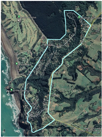
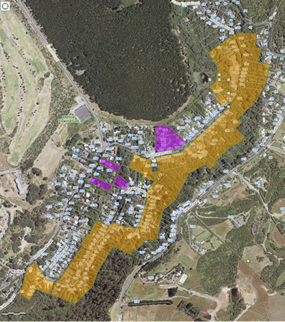
Fig 1: Overview of study area
Introduction
Landslides associated with Cyclone Gabrielle have shown that some homes in Muriwai are exposed to an unacceptably high landslide risk.
To inform the decisions about the future of these homes we need very robust information so decisions of local and central government are evidence based and consistent.
Auckland Council has been working with our geotechnical supplier, GHD, to collect this information and to understand the risk to life from large-scale slope instability in Muriwai (as well as Piha and Karekare). The results of this work will be used to inform land use planning and the revision of Rapid Building Assessment building placards.
The area being studied in Muriwai is shown in the graphic (pictured right), with the focus being on red and yellow placarded houses within the marked zone.
We’ve brought together a team of experienced and highly qualified experts to ensure the work is done efficiently and well. The team from GHD have significant experience, including:
- The Port Hills rockfall risk assessments through the recovery phase following the Christchurch earthquakes.
- The risk assessment for Fox Glacier access road and Department of Conservation access tracks in Westland Tai Poutini National Park.
- The geotechnical site investigations and geological assessments for the Penlink Project and the West-Auckland 2023 post-Cyclone Roading Network landslide damage geotechnical Investigations and assessments.
Timeline
In March we gave a rough indication that investigations would be likely to take three to six months. We are currently on track to complete the geotechnical risk assessment work in this timeframe, with the final report expected by late August. Further details are given in the timeline below.
These are estimates and will evolve as we collect more data and find out more about the complexity of the site. We will keep you informed of the results and any changes to the programme through this newsletter.
Muriwai Geotech programme timeline
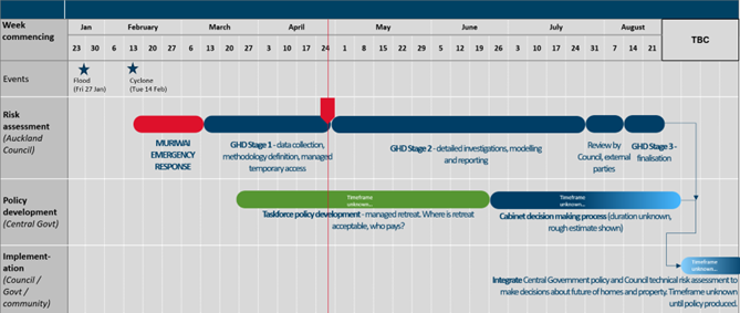
Fig 2: Outline timeline
The simplified timeline above shows how the project phases fit together, although there will be some overlap between the phases. It also shows a broad outline of the policy work happening in parallel in central government. This policy work (guided by the Recovery Taskforce, more information available on their 6 April 2023 Muriwai Newsletter) is needed to allow us to take the findings of the work by GHD and implement it.
Until the policy is delivered we won’t have clear guidance on what level of risk is acceptable for rebuilding, how any managed retreat might work, and what other options are available.
Learn more about the scope of the Recovery Taskforce.
Stage 1 of our programme is complete, and Stage 2 is underway. The work being undertaken by GHD in Stage 2 includes these main elements:
Desktop interpretation of the data collected throughout Stage 1 and into Stage 2. This will incorporate information from property files, geomorphology and the LiDAR data which give the background information needed for the risk assessment.
Field mapping to provide detailed information about each of the landslides and assess topographic features that will change the risk for properties.
Subsurface ground investigations and monitoring to provide detailed information on the locations of geological boundaries that affect slope stability.
Three-dimensional debris flow modelling for typical scenarios to inform the risk modelling and assist with risk communication.
Risk assessment following the procedures outlined in the AGS 2007 guidelines, which represent internationally accepted best practice. More information on these procedures is available on the Landslide Risk Management website.
Results
The work will assess the homes in Muriwai against two critical levels of risk defined by the Annual Individual of Fatality Risk (AIFR), which is the risk each person is exposed to from landslides every year by being in the home:
- 1 fatality in 10,000 years. This is commonly taken as the risk level that people are exposed to in everyday life for risks like driving and heart disease.
- 1 fatality in 1,000,000 years. This is a commonly accepted level of risk accepted for new buildings.
We’ve chosen these risk levels because they’re commonly accepted trigger levels both nationally and internationally, and so are likely to align with future policy settings from central government. For more information about levels of risk, see the Muriwai newsletter dated 8 March 2023.
The results will be presented in several ways, including maps, cross sections showing two-dimensional slope stability, and three-dimensional debris flow modelling. This three-dimensional modelling will give good evidence about how the debris flows are likely to travel in the Muriwai setting, allowing us to identify which homes are protected by the local topography so we can demonstrate that the risk is acceptable for them.
An example of the output of the 3D debris flow modelling is shown below:
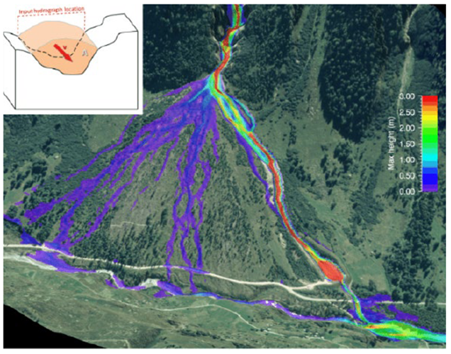
Fig 3: Example 3D debris flow modelling outputs (not from Muriwai)
Frequently asked questions
Who can I talk to for more information?
Every placarded property has been assigned a case manager to give you property-specific information. Although the team from GHD will be on site for some time, they won’t have the breadth of information that is available to the case managers, so we encourage you to direct your questions to our council team members.
How often will I get an update on progress?
We expect to provide updates every few weeks, with six in total between now and August, with the potential for more if there are any significant updates.
What should I expect to see from the field mapping?
GHD will be sending a small team of experts to undertake the mapping. Where it is safe, they’ll be physically walking over the landslides in small teams (likely two people) and recording the features they identify on tablet computers. The mapping will be looking at land only, and no access will be needed inside homes. The team members will be clearly identifiable.
What should I expect to see from the intrusive ground investigations?
A drill rig the size of small truck will be used to drill the boreholes. They create a hole about 100mm in diameter using low-impact drilling techniques to minimise disturbance to the ground. This will be operated by two drillers and supervised by an engineering geologist who will log the core. An example of the type of equipment we expect to use is shown below:
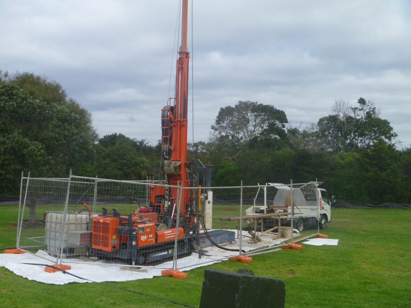
Fig 3: Typical drilling rig
It will take about a week to drill the hole at each site, install a sensor and then backfill the hole. A steel tube will remain in the hole to allow access to the sensor and data.
We intend to undertake this work on public land and will not do any drilling on private land without gaining permission from the landowner first.
Do I have to wait until August to get the results for my home?
It depends on the location relative to the higher risk slopes. During the work, evidence may become available that suggests that a placard should be changed. Within the group of houses given red or yellow placards, there will be some that are clearly very high risk, some that are clearly lower risk, and some in the middle.
A more rapid re-evaluation is more likely for the lower risk yellow (and in some cases red) placarded homes where there’s a realistic chance of a downgrade to white. Examples where this may occur include:
- We identify new information as part of our study that means re-evaluation of a dwelling placard can be brought forward.
- The homeowner or their insurer provides new information (e.g. a report or assessment by a geotechnical professional).
A reassessment of a placard will be done at the earliest reasonable opportunity for each home. Where it is identified that the placard status could be changed, GHD will prepare a short report and placard change recommendation, on behalf of the property owner, for the consideration of Auckland Council. This is in lieu of the normal process (see next question for details).
The houses that have experienced significant landslide damage have been demonstrated to be in a higher risk area. However, guidance for future actions for homeowners in these areas will require completion of central government policy and so it appears likely that decisions about these can’t be brought forward.
Should I get my own geotechnical advice?
It depends on whether you’re inside the exclusion zone. The normal process where a house has been given a red or yellow placard is for the owner (or their insurer) to engage the right engineering professionals to advise what steps are needed to remove a placard. If you’re outside the exclusion zone, this is the correct approach.
However, for those properties inside the exclusion zone Auckland Council is paying for a detailed area-wide assessment of the risk. We’re doing this because the risk covers a wide area, so a big-picture approach is the only rational way to fully assess the risk.
It is more efficient for Auckland Council to engage this work rather than have every homeowner pay separately. All results will be shared with you (and through you with your insurers). You are still welcome to get your own advice, but it is unlikely to add much value in addition to the work that Auckland Council will undertake on your behalf.
I’m in the exclusion zone but my placard doesn’t seem to match the F-angle lines, is it correct?
The maps presented in the 24 March 2023 Muriwai newsletter were based on a desktop slope stability assessment of the cliffs behind the property. This was then improved by undertaking an on-site assessment of every property in the exclusion zone to make the assessment more accurate. This allowed us to re-evaluate all the placards and reconfirm them. The placards given are based on the on-site assessment and supersede the information given in the F-angle line maps. Where an existing placard was re-confirmed as correct using this method, we did not replace the placard, so the reason written on the placard might not reflect this update.
Can the F-angle lines be refined further to allow access to more properties?
The F-angle approach only works well when it is based on a large dataset. The smaller the area covered by the assessment, the lower the validity of the results because there are fewer landslides to use in the model. The F-angle approach was useful as a first pass attempt and allowed us to change more than 90 homes from red to white, but we’ve pushed the technique as far as is possible – now we need to move to more advanced options. That’s why we have engaged GHD to work on more detailed geotechnical modelling that will provide greater confidence.
How do we know the results will be reliable?
Because it’s so important that we get this right, we have three levels of checking built into our work:
- GHD have robust internal review processes using experienced staff who worked on similar problems in the Christchurch Port Hills
- Auckland Council has an internal peer-reviewer who is reviewing the project as it progresses.
- We have engaged a separate external Geotechnical Advisory Panel comprising five of the most well-respected specialists in the country to review the methodology and end results.
8 June 2023 update
Placarding review advice updated
GHD have been monitoring the performance of slopes around Muriwai during the rainfall in May. MetService reported Auckland had its wettest May since records began in 1962, with 271mm recorded.
This gives GHD valuable information about the stability of the slopes and has allowed us to refine our approach to re-placarding and give more clarity to homeowners. These changes are shown in the figure below:
Map showing areas being investigated by GHD.
Properties are highlighted in different colours to show the different approaches to re-placarding that are now available based on this new assessment. It should be noted that this figure does not relate to the government announced buyout scheme. We need further assessment by GHD before we can confirm potential risk categories, and these will not be available until the GHD study is finished in late August.
The colours shown on the figure are:
Brown – These properties are likely to be within the influence zone of the debris flows from the main slopes in Muriwai. The placards for these properties will be reassessed following completion of the area-wide assessment by GHD. The results of this assessment are necessary to make these reassessments. Once the GHD work is complete (late August) each of these placards will be reassessed. Owners of these properties do not need to do anything for this to happen.
Purple – These properties are likely to be outside the influence zone of the debris flows from the main slopes in Muriwai and have not been affected by smaller-scale local landslides. GHD is working on reassessing the placards of these properties. Owners of these properties do not need to do anything for this to happen.
No colour (including those off the map) – These properties are likely to be outside the influence zone of the debris flows from the main slopes in Muriwai. Some have been affected by smaller-scale local landslides, resulting in placards.
Because these small landslides require site-specific remediation or assessment, we recommend that the owners of yellow or red placarded properties in this zone contact their insurers and engage a professional geotechnical engineer or engineering geologist to inform them about the next appropriate steps.
Owners of properties in the purple or brown zones are welcome to get independent geotechnical advice. In general, for these zones, we do not recommend this, as it will be expensive and not provide any value over the work being undertaken by GHD.
12 July 2023 update
Geotechnical update – stage 2
After commencing on 29 June, drilling is progressing well at Muriwai, with two of the nine boreholes completed with a third currently underway – a total of 110 metres drilled to date, of the 360 metres proposed.
Currently completed locations are BH-M01 (Oaia Road) and BH-M08 (Motutara Road), with BH-M07 (Motutara Road) currently being progressed (Figure 2, below). The next location to be drilled will be borehole BH-M09.
One of the six proposed piezometers (to measure groundwater) have been installed successfully, with the second to be installed upon completion of the current borehole on Motutara Road (BH-M07). Telemetered groundwater monitoring equipment to automate ongoing monitoring of groundwater will be installed once drilling and installation of all locations has been completed.
There are three remaining holes to complete on Domain Crescent, two on Oaia Road, and one on Motutara Road. We thank the community for your patience with traffic management and the teams on site.
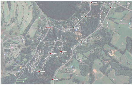
Figure 2: Drilling locations (Red dots)
20 July 2023 update
Re-placarding
As part of the ongoing geotechnical assessment of land stability and risk to properties in Muriwai, engineering firm GHD identified a group of properties that are likely to be outside the influence of the debris flows from the main slopes and have not been affected by smaller scale local landslides.
GHD recommended to the council late last week that 11 properties could have their placards downgraded. Final inspections of these properties by compliance staff took place early this week, and property owners have been informed, with a formal placard change letter to follow. In some cases, this will mean that some people can return to their homes, which is great news. The council is really pleased to be able to safely return people to their homes after several months.
The evaluation of the wider Muriwai area is ongoing, and we expect to receive the recommendations by late August. The findings of this report will feed into the separate process of applying the Government’s property risk categories to homes in Muriwai, and we’re looking forward to being able to provide certainty to more homeowners when we can.
Geotechnical update – stage 2
Further progress has been made on drilling in the past week at Muriwai, with five of the nine boreholes completed and drilling commencing on Domain Crescent. A total of 150 metres have been drilled to date, of the 360 metres proposed.
Currently completed locations are BH-M01 (Oaia Road) and BH-M08, BH-M07, BH-M09 (Motutara Road), BH-M05 (Domain Crescent) and are currently drilling BH-M06 (Domain Crescent) (see Figure 1 below).
There is one remaining hole to complete on Domain Crescent and two on Oaia Road. Plans are for drilling to be completed in Muriwai in early August.
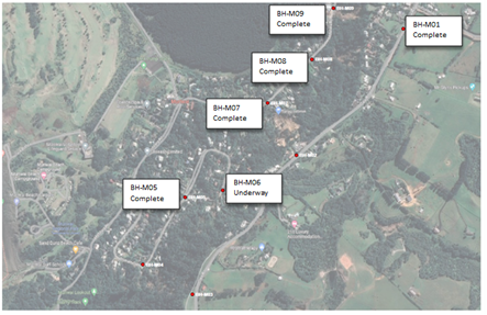
Figure 1: Drilling locations (Red dots)
27 July 2023 update
Engagement with affected property owners in the geotechnical study area
The planned sequence for communicating the outcome of the GHD programme to homeowners within the GHD study area is:
- Meeting for affected homeowners within study area on Tuesday 29 August. We will contact this group directly with a meeting invite. A draft copy of the geotechnical report will be provided to property owners ahead of the meeting.
- At the meeting, Ross Roberts, Head of Engineering Resilience, will explain the report and answer your questions.
- This will be followed by a 5-day period for feedback before the report is finalised. This is something which has been requested by property owners. Following the close of the feedback period, feedback will be considered, and the report finalised for publishing.
Based on the findings of the report, property owners will receive confirmation of whether their home is inside the risk zone (and therefore in Category 3) or whether they are outside the risk zone and can have their placard downgraded.
Geotechnical update – stage 2
Another drillhole was completed and piezometer (groundwater monitor) installed at Muriwai last week, with six of the nine boreholes completed – a total of 190 metres drilled to date, of the 360 metres proposed. Drilling will be back on Oaia Road for the rest of the week.
Currently completed locations are BH-M01 (Oaia Road) and BH-M08, BH-M07, BH-M09 (Motutara Road), BH-M05 and BH-M06 (Domain Crescent) and are currently commencing drilling BH-M03 (Oaia Road) (Figure 1 – see below).
There is one remaining hole to complete on Domain Crescent and one on Oaia Road.
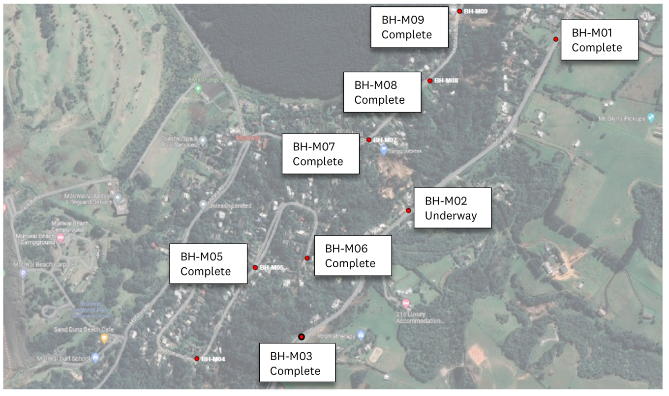
Drilling locations (red dots)
9 August 2023 update
Completion of another 80m drillhole at Muriwai marked the seventh of the nine planned holes in the study completed. Drilling will continue Oaia Road on borehole BH-M02. Remaining drillhole BH-M04 on Domain Crescent is due to be completed week of 14 August (see image below).

Ground investigations have progressed well. The critical data so far has been included in the reports that will be released in draft at the end of August. The extracted drillcore has shown expected geology, such as Awhitu Sand Formation in BH-M03 (drillcore image below). Samples are due to be sent to a laboratory for testing and ground water monitoring will continue beyond the completion of the programme.


16 August 2023 update
Placard downgrade process
This week Auckland Council expects to receive GHD’s preliminary risk assessment for Muriwai, and we expect some properties could have their placards downgraded. A process of peer review of this information and review with compliance staff is anticipated to take five working days.
Final inspections of these properties will be carried out by Auckland Council compliance staff this will be a check over the property prior to allowing people back just to ensure there are no issues. The property owners will receive confirmation via email, with a formal placard change letter to follow as GHD’s risk assessment is finalised. In some cases, this will mean that some people can return to their homes safely.
If in the case where some properties go from a red to nothing, the owner will be able to remove the placard themselves.
Drilling complete
Ground investigations will be completed in Muriwai this week. Total of 360m drilled.
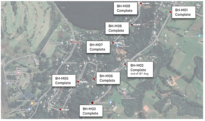
Drilling locations (red dots)
Muriwai geotechnical update: 14 September
GHD draft report next steps
The draft GHD landslide risk assessment report for Muriwai is currently being finalised. This includes reviewing feedback received from affected property owners and being peer-reviewed by a panel of independent geotechnical and engineering experts. The final report will be available early October. With this report, and a separate mitigation report from GHD (expected in the same timeframe) we will be able to confirm initial property categories.
Process for category 2/3
Muriwai properties that were given an initial ‘category 2/3’ are having further assessment by GHD to see whether the risk to life at the property that’s been identified through their geotechnical study, can be reduced to a tolerable level with a practical engineering solution.
As part of this detailed property-level assessment, GHD will be undertaking the costings for the mitigation work, because the cost of the intervention is a factor that will be considered in the final category.
GHD have identified the 2/3 properties where some further site visits are required. The site visits will happen on Wednesday and Thursday next week – property owners don’t need to be present so there’s no need to take time off work or travel to Muriwai if you’re living elsewhere, but a member of the council team will call property owners ahead of time to seek your permission for GHD to go onto your property.
Muriwai geotechnical update: 21 September
Next steps for Muriwai residents who have not received a category letter
For those Muriwai residents who did not receive an initial property category on 28 August but have either had a building placard and/or filled out the Flooding and Landslide Registration Form, we are in the process of contacting you to confirm any remaining actions that may be needed.
We will be communicating via email (keep an eye out for an email from propertycategorisation@aucklandcouncil.govt.nz over the next week) or if we don’t have your email, via post. If we need to communicate by letter, this will take some time due to delivery of a physical letter.
Please note that property categorisation and building placards (red, yellow and white placards) are different. Property categorisation looks at future risk whereas placarding looks at immediate safety risks and whether your property is safe to be in now.
If you would like to provide us with your email address, please send your name, address and email address to muriwai@aucklandcouncil.govt.nz.
GHD site visits to Muriwai
As mentioned in last week’s newsletter, GHD will be conducting further site visits this week for selected initial ‘category 2/3’ properties (and in some cases neighbouring properties) and the general area. This is for GHD to investigate the feasibility of any mitigation measures and whether these measures will be cost effective. This information will be used to determine whether the category is either 2 or 3.
Affected property owners have been informed of the visits, and as soon as the outcome of these further 2/3 assessments are known, we will communicate directly with them. We can’t confirm a date at this stage, and we recognise this is frustrating for these property owners. We are hoping this will be early-to-mid October, but we will keep you posted.
If you haven’t been contacted for a site visit, this does not mean your property is not being looked at by GHD. All initial ‘category 2/3’ properties are being investigated either by desktop assessment or on-site assessment. We appreciate your patience as the process continues.
Please note that while GHD are onsite, they will be unable to answer property owner’s questions due to time restrictions. Instead, please email your questions to propertycategory@aucklandcouncil.govt.nz.
Muriwai geotech update: September 28
Mitigation options for 2/3 properties
Thanks to all property owners for access to their properties last week. GHD was able to gather some additional information from the area to add to their screening of mitigation options. They were mainly gathering information on access to each site or group of sites all considering debris flow hazards and construction practicalities.
GHD will compile potential mitigation options, note localised landslides then provide the proposed mitigation(s), size and whether it is within the property being protected, or elsewhere. Some examples of potential mitigation options include flexible barriers (figure A), as well as rigid and reinforced barriers (figure B). A brief description of more common protection measures is shown in the table below:

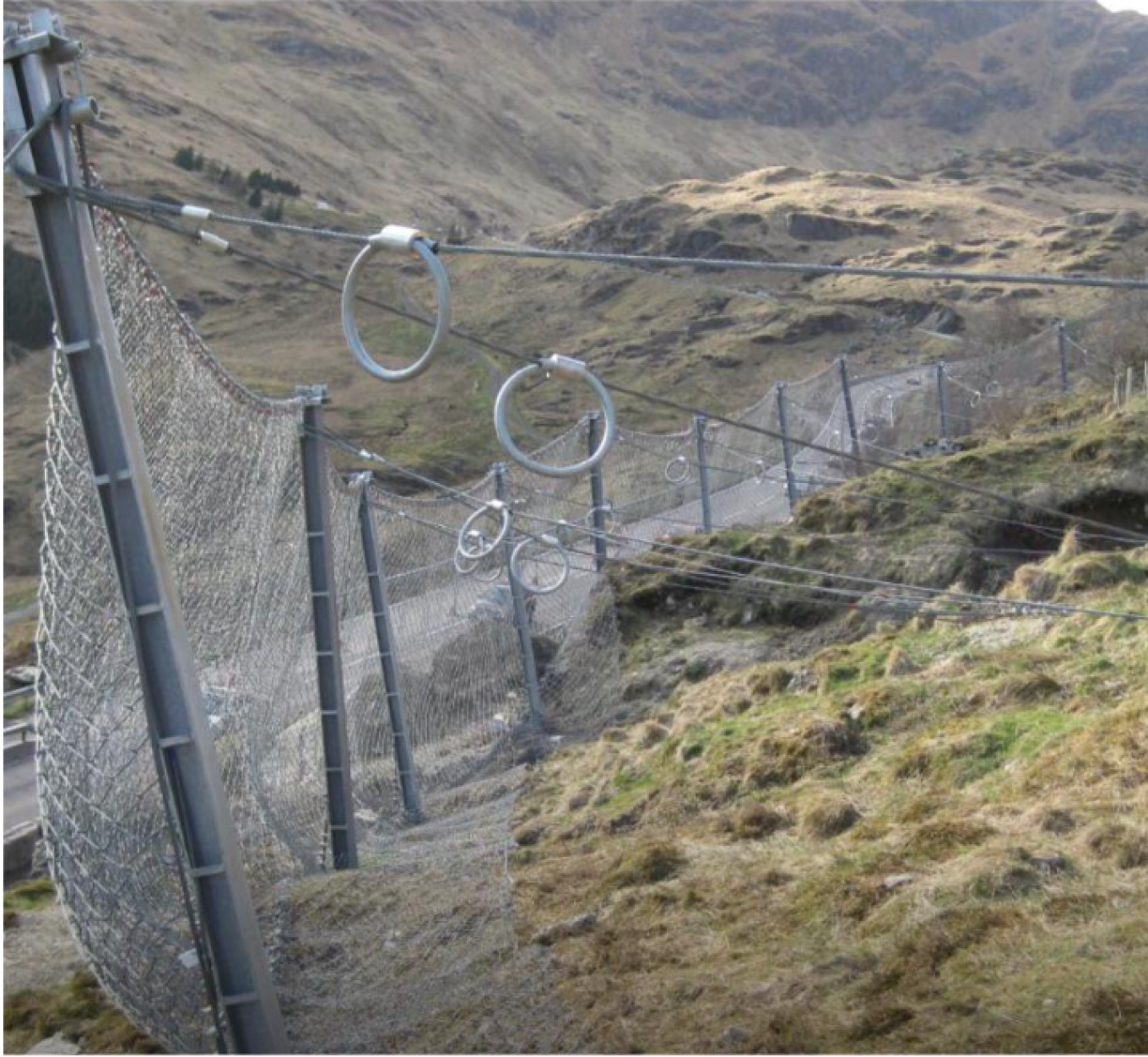
Figure A – Example flexible barrier system (source GeoBrugg)

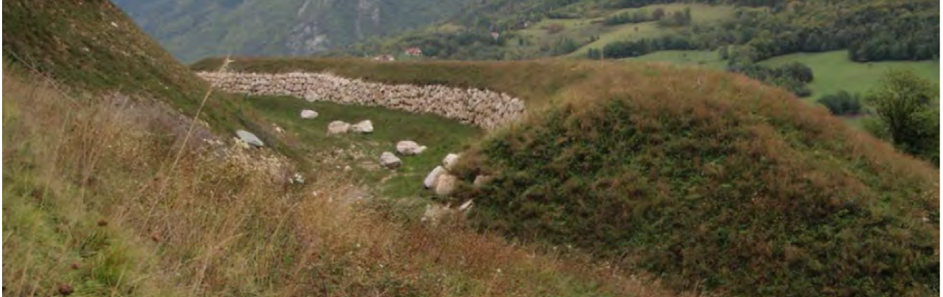
Figure B – Example rigid deformable barriers (including reinforced embankments)
These options are partly dependent on where protection is required along a slope profile i.e. closer to the source of the landslide or further away from the source and in the ‘run out’ zone. A typical application of these options is shown below. Taking a flexible barrier as an example, it can in theory work as a potential barrier system from the base of steep slopes and anywhere else through the potential run out zone.
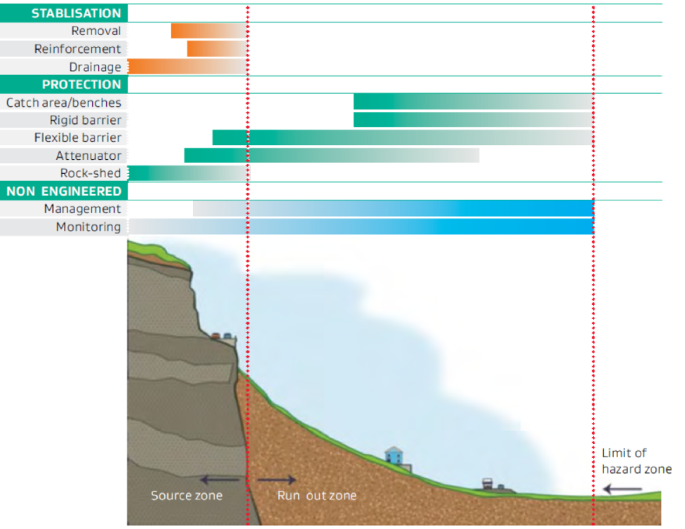
Figure – Typical application of mitigation measures along slope profile
Indicative costs
GHD will be providing an assessment of the indicative costs of these options, where they’re viable, to assist with the categorisation process. This will also include maintenance costs. These costs can be quite considerable, particularly if regular debris removal is required at a site which is difficult to access.
Final report
Thanks for the feedback submitted this has all been reviewed by GHD and will be taken into consideration for the final report release in October.
Muriwai geotechnical update 11 October
Category 2 and 2/3 properties
Later this week, GHD will provide us with the mitigation results for properties. This will then allow our independent Geotechnical Advisory Panel to peer review the results.
As we signalled last week, we are also waiting on the Governing Body meeting on 26 October to make policy decisions on what mitigation is affordable and feasible – this policy decision will determine whether properties are either category 2 or 3.
Incorporating your feedback into the Muriwai geotechnical report
The revised Muriwai Landslide Risk Assessment report will be received in early November. This will include amendments to reflect the feedback we’ve received from the community, as well as the key changes proposed by our independent Geotechnical Advisory Panel.
We anticipate that there will also be a second revision released to close out minor technical review comments only (for example providing more detailed references) from the geotechnical advisory panel. This will be the final version. We do not expect this second revision to contain any changes that will affect the categorisation of your property. Our intention by delivering two iterations is to enable the technical findings to be published at the earliest opportunity while some tidying up of the report takes place in the background.
We know that that this delay is extremely frustrating and will cause anxiety. We have engaged two additional engineering consultancies to take up some of the work that GHD have been doing in Piha and Karekare, freeing up GHD to deliver the risk assessments and Muriwai report as quickly as possible.
Muriwai geotechnical update: 26 October
Initial category 2/3 properties
GHD have completed geotechnical mitigation options for Muriwai properties that were given an initial category 2/3. These mitigation options are currently under internal and external peer review. Once these reviews are complete and once we have the Governing Body decisions from today’s meeting, on what are feasible and affordable mitigation options, we can start confirming their final category numbers over the next few weeks.
We appreciate your patience while we complete this important mahi and we are working with our suppliers as quickly as possible to give you the closure that you need.
Final report
GHD are working to address the community feedback received on the draft Muriwai Landslide Risk Assessment Report, which will be re-issued in early November.
As mentioned previously, there will be a further final release of this report to address the minor technical review comments at a date still to be confirmed with the GHD team.
Muriwai geotechnical update: 16 November
The Tāmaki Makaurau Recovery Office is continuing to give Muriwai property owners their finalised property categories. We are working as quickly as possible on this and appreciate your continued patience. If you need any wellbeing or social support please speak with your Navigator or email navigators@aucklandcouncil.govt.nz.
We’ll give affected property owners in the GHD study zone the first release of the final Muriwai Landslide Risk Assessment Report, and if applicable, the Muriwai Mitigations Options Report.
The second (and final) release of the Muriwai Landslide Risk Assessment Report will be made publicly available. We will let you know via this newsletter when we have a timeframe for this – GHD is aiming to have it ready before Christmas.
