
Revised timeline for GHD assessment
GHD has nearly finished conducting assessments of affected properties in the Piha and Karekare areas. GHD’s assessment included geotechnical site inspections and the assessment of damage from landslides.
As part of the ongoing geotech fieldwork, drone surveys will be undertaken for properties with restricted access from the week starting Monday 18 September 2023. We have been liaising with landowners of affected properties to obtain permission prior to flying the drones. We would like to express our thanks to the homeowners who have given us permission to undertake these surveys. We do encourage your cooperation as it enables us to provide the most comprehensive geotechnical assessment possible, while helping us keep the programme of work on track and avoid further delays. Final permission for these drone surveys can be given up until Monday morning, 18 September.
Over the next two weeks, GHD will revisit some properties at both Piha and Karekare to gain additional technical information, and be present for some of the drone surveys where there are access restrictions. Geotechnical reporting will continue at the same time for the remaining affected properties.
Drone surveys and orthomosaic imagery are very useful for geotechnical assessments as they can provide a detailed view of the entire site, provide high-resolution aerial imagery and topographic data. Orthomosaic images stitch together multiple individual photos (“orthophotos”) which are then overlapped to capture a comprehensive view of an area. Orthophotos can provide site overviews, precise measurements of landforms and features and terrain analysis, to create digital elevation and surface models for geotechnical analysis.
Timeline for release of GHD’s draft reports
Unlike Muriwai which had two large escarpments and associated large scale instability, the landslides in Piha and Karekare consist of numerous localised landslips and land instability. Because of this, it is more appropriate for GHD to produce multiple reports – one per landslide or area of instability. In some cases, reports will cover single properties, while others will include multiple adjacent properties.
Due to the number of reports being produced, we will be releasing GHD’s draft reporting with property owners in Piha and Karekare in tranches, as the reports become ready. This approach means that individual property owners will get their information as soon as practically possible, rather than waiting for every report to be completed.
Affected property owners will be emailed a draft geotechnical report and their initial property category, and will have the opportunity to provide feedback and discuss the report one-on-one with a geotechnical expert.
We will be contacting property owners directly over the next week to advise them of next steps, including whether they are impacted by GHD study and, if so, when they will receive a draft report and invites for follow-up discussions with technical experts.
Auckland Council will use GHD’s reports to inform decisions on final risk categorisation, as well as reviewing RBA placards.
Timeline for upcoming engagements
Community meetings, Saturday 23 September
The purpose of these meetings is to provide updates on the categorisation and risk assessment processes, and provide an update on the progress of the GHD study. At this meeting, we will explain how the placard review process will work once the geotechnical findings are available, so the next steps are clear for you.
All members of the Karekare and Piha communities are welcome to attend these meetings.
At each of these meetings, Auckland Council Head of Resilience Ross Roberts will discuss the geotechnical reports and answer any questions you may have.
Piha community meeting – 10am – noon, Barnett Hall, 2 North Piha Road, Piha
Karekare community meeting – 2–4pm, Karekare Surf Club, 34 Watchmans Road, Karekare
Release of GHD reports and initial property category
Reports will be released in clusters based on when they are completed by GHD. These clusters are:
-
Karekare – Last week of September
-
Piha – In two clusters across the first two weeks of October
Exact dates will be confirmed directly to affected property owners once confirmed.
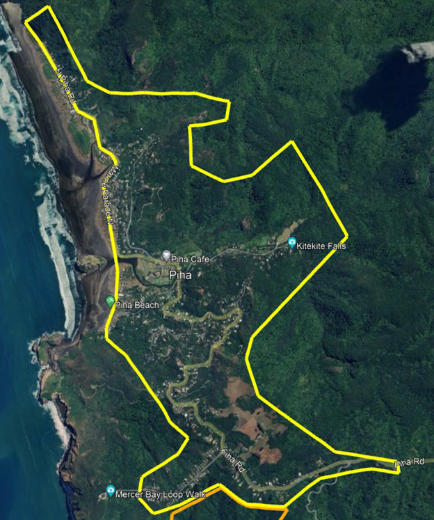
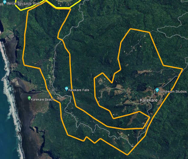
GHD assessment area
The assessment areas are shown in the maps below.
Piha assessment area:
Karekare assessment area:
Categorisation
GHD’s draft reports will be used to provide initial risk categorisation for homes that are in the identified sub-zones of risk. If your home is outside these areas but you think your property is high risk and want to be considered for categorisation, please fill in our flooding and landslide registration form here.
The definitions of the categories are shown below:
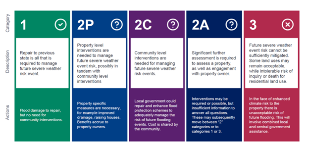
Our risk categorisation approach in Karekare and Piha is the same as in Muriwai. Initial categorisations will be either:
- Category 1 (risk is tolerable); or
- Category 2/3 (risk is intolerable)
Why categories will be ‘initial’
We will email each individual property owner with a letter giving you an initial category. An ‘initial’ category is needed because work to define the risk threshold is still in progress. Until this is complete, we can only give you an initial category. We’re expecting the policy work to be completed in early October, subject to Governing Body decisions.
Property owners will be able to discuss this initial category with us if they disagree with it. We’ll explain this process to you when your initial category is communicated to you.
Where a property is placed into Category 1, this will be final (subject to your feedback and peer review). No further investigation or information will be needed in addition to the GHD study.
Where a property is placed into Category 2/3, it means that further assessment for your individual property is needed to identify what mitigation measures are actually practical to reduce risk the risk to your home to a tolerable level. To understand this, GHD will determine a costed concept design for the mitigation. Based on that information, your property will be confirmed as either category is Category 2 or Category 3.
We will be working through both requirements in October with the intent of having final results for the majority of properties by the end of October.
Re-placarding
GHD advised the council that a number of properties in Karekare could have their placards downgraded geotechnically. (Note: these properties may still have a placard for non-geotechnical hazards, such as risks associated with structural, flooding, etc.)
Final inspections of these properties will be undertaken by Auckland Council compliance staff, and the property owners will be contacted and informed regarding the outcomes for placard removal/downgrade. This will be followed by a formal placard change letter. In some cases, this will mean that some people can return to their homes.
Getting people back into their homes at the earliest safe opportunity is our top priority, so this work will be happening in some cases before reports have been finalised.
FAQs
You may wish to read our Recovery FAQs for further useful information about property categorisation, buyouts, placards and rates relief, or our property categorisation explainer on OurAuckland, which includes a video update on property categorisation from Deputy Group Recovery Manager Mace Ward.
If there are any other questions you would like answered, please email them to us at piha@aucklandcouncil.govt.nz or karekare@aucklandcouncil.govt.nz and we will address these at the Saturday 23 September community meetings in Piha and Karekare.
Stay up to date
Sign up to the recovery e-newsletter to get the latest updates direct to your inbox.
