

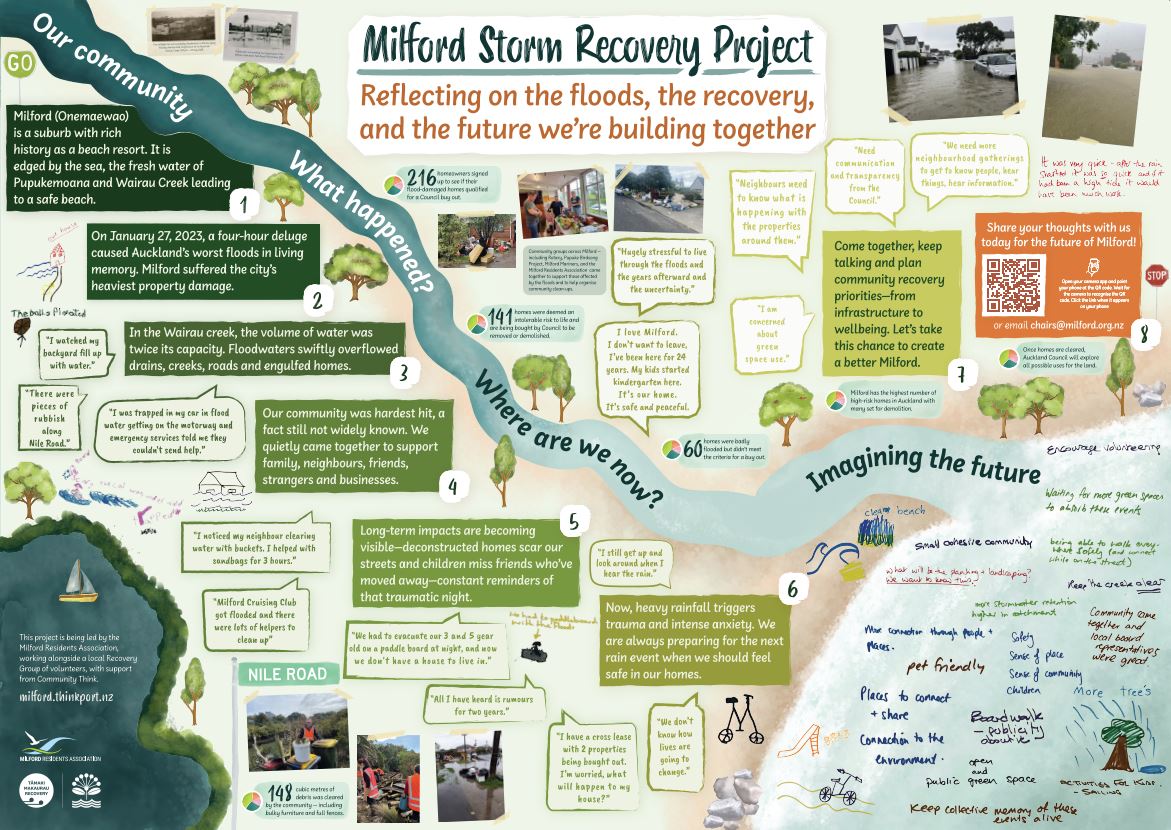
The suburbs surrounding the Wairau Creek on the North Shore were some of the hardest hit during the 2023 floods, with the tragic loss of two lives and millions of dollars of damage to homes and businesses. Surf lifesaving volunteers rescued 69 people from the area, and more than 250 homes in Milford, the Wairau Valley and surrounding suburbs received red (significant damage) or yellow (moderate damage) placards.
In particular, Milford, which also has the highest number of Category 3 homes of any suburb in Auckland, alongside neighbouring Sunnynook, Forrest Hill, and Totara Vale were heavily impacted.
Category 3 progress: 21 May 2026
|
|
Category 3 properties |
Buy-outs settled |
Shared ownership properties |
Houses removed |
|
Milford |
138 |
134 |
114 |
58 |
|
Forrest Hill |
9 |
9 |
- |
5 |
|
Totara Vale |
13 |
13 |
5 |
6 |
|
Sunnynook |
9 |
6 |
5 |
1 |
|
Total |
169 |
162 |
124 |
70 |
House removal activity continues in the main Milford cluster, with significant progress having been made in the Nile Road and Woodbridge bridge area.
We continue working through shared ownership approvals and removal assessments across Wairau, including plans for further removals in Sunnynook, Sunnynook and Forrest Hill. Clusters can only be confirmed subject to owner agreement and technical checks.
As we confirm detailed plans for each cluster, we’ll inform direct neighbours and previous homeowners, while keeping the wider community updated about the general programme of work.
Ngā Wairau flood resilience project
The next big chapter is taking shape at AF Thomas Park, where construction on Stage 1 of the Ngā Wairau flood resilience project begins in late 2027, increasing stormwater holding capacity for the area.
The Kaipātiki Local Board confirmed the direction for recreational activities for the remaining area of the park which will include a mix of golf, sports fields and space to enable indoor sports and events. With recreational outcomes now confirmed, the team is moving into detailed master planning, including design and leasing arrangements.
The Woodbridge Lane bridge has been removed to reduce interim blockage risks, and the team is working on design and a funding business case for early 2027 to progress Stage 2 works, covering further Wairau catchment flood risk reduction.
Ongoing stormwater work and preparedness
The council has increased stormwater maintenance and monitoring in the area. Stormwater network improvements include:
- 36 Hotspots inspected monthly and before storms
- 5 hotspot monitoring cameras installed to identify blockages for faster removal by operations teams
- Increased catch-pit cleaning of 2,500 locations
- New water quality treatment device installed
- Watercourse at Bryan Byrnes Reserve dredged, desilting of Link Drive pond
- Upgrading to 'back-entry' catchpits that still take in water if the top grate is blocked.
Alongside this we are working with the community to help reduce dumping around streams and increase storm preparedness. In Milford we have partnered with Pupuke Birdsong to improve local flood knowledge, expand stream restoration efforts, and support stormwater management. For more information get in touch with Pupuke Birdsong or keep an eye out for local events!
Flood risk categories
The council has assessed homes affected in the 2023 storms that registered for a future risk category, offering buy-out or construction grant support depending on the risk.
Visit our Tāmaki Makaurau Recovery Office website for more information, or these pages on the council website for detailed information about each category:
- Category 1: 85 homes across Milford, Forrest Hill, Totara Vale and Sunnynook were cleared of having an 'intolerable risk to life' from future flooding and landslides
- Category 2P: 4 homes across these suburbs were identified as having an 'intolerable risk to life', but are receiving support to implement solutions at their home that will reduce this risk to a reasonable level
- Category 3 : 169 homes in these suburbs were identified as having an 'intolerable risk to life' but there is no viable solution to reduce the risk to a reasonable level. These homeowners have been offered a buy-out to help them move out of harm's way.
Wellbeing support
Various community and wellbeing support is available for storm-affected residents, including free help with processing home insurance claims, rates relief, temporary accommodation assistance, and wider financial and mental health support. Check out the available wellbeing resources on OurAuckland.
The Storm Recovery Navigation Service closed as of December 2025, as many of the whānau affected by the 2023 severe weather events have moved forward in their recovery journey.
Removal of high-risk homes
Auckland Council is removing high-risk Category 3 homes that were part of the voluntary buy-out programme (and continuing to look at how we make Category 3 units within multi-unit complexes safe). But with over 160 Category 3 homes that could be removed, we know this will bring significant change to the neighbourhood — and we’ll ensure it’s managed with care.
Getting to the point of being able to remove a home requires working alongside neighbouring homeowners, some of which have shared ownership situations with our Category 3 properties. In addition to this, some buy-outs are not yet finalised. This takes time and we thank everyone very much for their cooperation.
How homes will be removed
Most homes will be removed or deconstructed, with around a third relocated for use elsewhere (and we'll continue to look at how we make Category 3 units within multi-unit complexes safe). Salvageable materials will be sent to recycling partners for reuse.
When we have legal access and co-owner agreement, a series of technical checks must be completed before removal work can start. These may include geotechnical assessments, asbestos testing, choosing the safest removal method, confirming access requirements, and arranging any required consents or traffic management.
Where homes share driveways or sit closely together, removals may need special approval or to be carefully sequenced with neighbouring properties.
As we confirm detailed plans for each cluster, we’ll inform direct neighbours and previous homeowners, while keeping the wider community updated about the general programme of work.
Active work areas will be fenced-off and clearly signposted with contractor information and work dates - so keep an eye out for the signs.
Shared ownership challenges
A large proportion of Category 3 properties in these suburbs are complex, with 124 properties (over 73%) involved in cross-leases or unit title situations. These take extra care and require agreement with remaining co-owners, under their lease or body corporate rules, before house removal and other actions can go ahead. Once agreement is reached, Council works with owners to update land titles, and this can be quite complicated on some sites.
Many of these discussions are still underway, which means we cannot begin removal work on many of the properties yet. We thank these homeowners very much for their cooperation.
Keeping you updated
Given the complexities, we don’t yet have dates for every site. However, we will notify neighbours as soon as a property is ready for works to start. Once all pre-removal requirements are complete, we will schedule the removal as soon as possible, also letting previous homeowners and nearby residents know.
Maintenance/security of Category 3 homes
After settlement of a property, Auckland Council provides a basic level of maintenance. The focus is on maintaining areas visible from roads and footpaths i.e. berms and front yards on properties that have road frontages.
Until we take ownership, the private property owner is responsible for maintaining the site. You can report an issue with a council-owned property using the ‘Report a Problem’ tool on the council website, under the ‘community venues, parks, beaches and other spaces’ heading.
As expected, empty homes can attract vandalism and break ins (one of the reasons we are trying to manage the sharing of Category 3 addresses). In some situations we are boarding up homes, in others we have cameras or undertake patrols. You can help by reporting anything suspicious or threatening to the police as soon as possible.
For questions about maintenance/security of storm-affected homes check out the FAQs.
Unit title and cross-lease owners
We acknowledge how complex and emotional these situations are — particularly for homeowners in shared ownership situations concerned about the future of their own home. So we recognise the importance of ongoing communication in these situations.
In unit-titles and cross-lease situations we’ll notify other owners on the property after a sale is agreed with council, keep them updated of our plans, and seek written approval where required for any activities. Plans could involve making the site safe, exploring non-residential uses, or other appropriate options.
For more information see our multi-unit and cross-lease FAQs.
Future use of storm-affected land
We have a region-wide policy that guides what we do with this land. Our top priority is always safety — but we also need to make sure we’re delivering good value for Aucklanders, especially given how expensive these buy-outs have been. You can find the policy online at ourauckland.nz/futureuse.
Essential use or hazard management
We're considering how Category 3 land can support essential council services like flood mitigation, which will save Aucklanders money in the long run. We expect around half of the properties to remain with council either because they're useful or need management due to high hazard risks.
Opportunities for sale
But holding onto land has ongoing costs. If a property isn’t needed for essential council services or hazard management, we’ll consider selling it where’s it’s safe to do so.
Some sites may become safe for redevelopment by building on less hazardous areas or having the risk reduced through measures like flood protection upgrades.
If the land isn’t essential or redevelopable, other sale options will be considered, such as backyard extensions for neighbours or rural grazing. Due to the hazard, there will be limitations on use.
Community uses
We’re working with local boards and mana whenua to explore community uses for land where council services or sale aren’t viable. This could include parks or open spaces in areas that lack them – particularly where funding is available to support these initiatives.
Interim uses
In the meantime, we’re considering safe temporary uses with supporting guidelines. Community groups and organisations can apply to use this land for low-risk, non-residential activities like planting, grazing, play equipment, or temporary events. Guidelines are available at ourauckland.nz/futureuse.
Got a land use suggestion?
After looking at the guidelines you can make suggestions for future or interim uses at ourauckland.nz/futureuse. We’ll only get in touch when we have an update – this will take time.
Looking forward: Community recovery planning
The Tāmaki Makaurau Recovery Office is working alongside the Milford, Forrest Hill, Sunnynook, and Totara Vale community as they adapt and prepare for any future events.
With hundreds of affected homes to be removed across Auckland, the changes can lead to feelings of uncertainty. Connecting with friends and neighbours helps to normalise these feelings and reminds us we’re not alone in our experiences.
Having opportunities to participate in how your community adapts to your new normal and prepares for any future events is also important. Join in community recovery activities in your community:
Milford recovery planning
A Community-led Recovery Planning Report has been created to highlight the priorities of Milford locals, and set the scene for next steps in the community's recovery.
- View the Milford Recovery Planning Report
- Get involved in next steps by contacting the Milford Residents Association chairs@milford.org.nz
Totara Vale, Sunnynook, Forrest Hill recovery planning
A people-led PACT for Sunnynook, Totara Vale and Forrest Hill will help guide the community through the next steps of its long-term recovery from the major 2023 storms.
- View the Sunnynook Catchment PACT
- Get involved in shaping how the PACT will come to life by contacting the Sunnynook Community Centre snook.com.cen@xtra.co.nz.
Flood awareness and preparedness
There is a lot of information available about flood risk in communities and at homes, with a key resource being the Auckland Council Flood Viewer where you can search to find Auckland addresses. Connected to this, there is some fantastic information to help you reduce the flood risk at your home and keep your family prepared.
An Emergency Readiness Plan has been prepared for the Devonport-Takapuna Local Board area based on its unique geographical, social and hazard profile. The plan identifies the local board area’s top hazards and provides tips on reducing risk, preparing for emergencies, and navigating the recovery process. A handy key contacts and information summary sheet for easy access tips. Milford also has its first emergency community hub at the Milford Cruising Club.
Reporting flooding, dumping and stormwater blockage issues to 09 301 01 01 will ensure the council can address issues as soon as possible.
Understanding Auckland's flood hazard information
In Auckland, we’ve seen how natural hazards like flooding, coastal erosion and landslides can impact people, homes and businesses.
We’re also seeing more Aucklanders interested in knowing about their flood risk including when they’re looking to purchase property or move into a new rental property. This includes checking the flood hazard maps on Auckland Council’s Flood Viewer or Geomaps beforehand, or by purchasing a Land Information Memorandum (LIM) report.
Visit our flood maps explainer for some useful information on how and why we publish these maps, and what they mean.
Managing development in hazard areas
Auckland Council wants to allow more housing choice - but in the right places. Since 2023 floods Auckland Council has been advocating to the Government for the power to be able to strengthen planning rules even further
Stronger planning rules for Auckland hazard areas came into force on 3 November 2025. These are key elements of Plan Change 120 which seek to restrict building in high hazard areas and strengthen the standards that must be met by developers when applying to build in these areas.
There are maps showing zones that determine what kind of development will be allowed where – to ensure building happens in the right places. However, regardless of what planning zone a property is in, strict consenting rules will apply for any development being proposed in a hazard area. They will have to show the risk can be mitigated and not impact neighbours etc.