
Mercury Lane and Beresford Square, two upgraded public spaces framing the forecourts of Karanga-a-Hape Station, are finished and now open for the public to explore.
This milestone completes many years of complex construction works above ground, preparing the area for the opening of the City Rail Link (CRL) in the second half of 2026.
The improvements - led by Auckland Transport and supported by Auckland Council and NZ Transport Agency Waka Kotahi (NZTA) - include upgrades to Pitt Street, Beresford Square, Mercury Lane, Cross Street, Canada Street and East Street.
The works include new footpaths, bus stops, bus lanes, bike lanes, rain gardens and public art in redesigned streets and spaces around the station.
Councillor Andy Baker says the upgrade of station neighbourhoods, the CRL itself and the CRL-enabled timetable will improve how the city moves, grows and competes.
“When you look at the big modern cities, they are all premised on having a really well functioning, efficient and attractive public transport network based on rail, generally.
“Looking at all four CRL station precincts, the one I think is going to go nuts is Karanga-a-Hape. It’s one of our most iconic places in the city. It mirrors a lot of the funky, cosmopolitan parts of other big cities – like Fitzroy in Melbourne,” Councillor Baker says.
“I'm really looking forward to being able to jump on a train down the road from my place in the south, exit the station at Mercury Lane, and head to St. Kevin's Arcade with its awesome restaurants, or the other eclectic parts of Karangahape Road,” he says.
Auckland Council Director of Resilience and Infrastructure, Barry Potter, says the CRL is a real driver of positive change across the region.
“The CRL’s new stations will also drive development, just as Waitematā Station has in downtown. We’re seeing high quality development around the stations, and that's massively important. It has a catalyst effect,” he says.
Next station neighbourhood - ready
First it was the Waitematā Station neighbourhood in downtown that was completed. And now Aucklanders can experience the next completed CRL station neighbourhood.
We’ve created a ten-stop walk along Karangahape Road, taking in many of the newest design elements and discovering how they reflect this area’s unique history and identity.
1. Pāua bus shelters
These are much more than bus shelters, sitting on the motorway overpass at the Ponsonby Road end of the main street. The layers of colour symbolise the pāua-shell eyes of Māori carvings reimagined into a material adorning the structures.
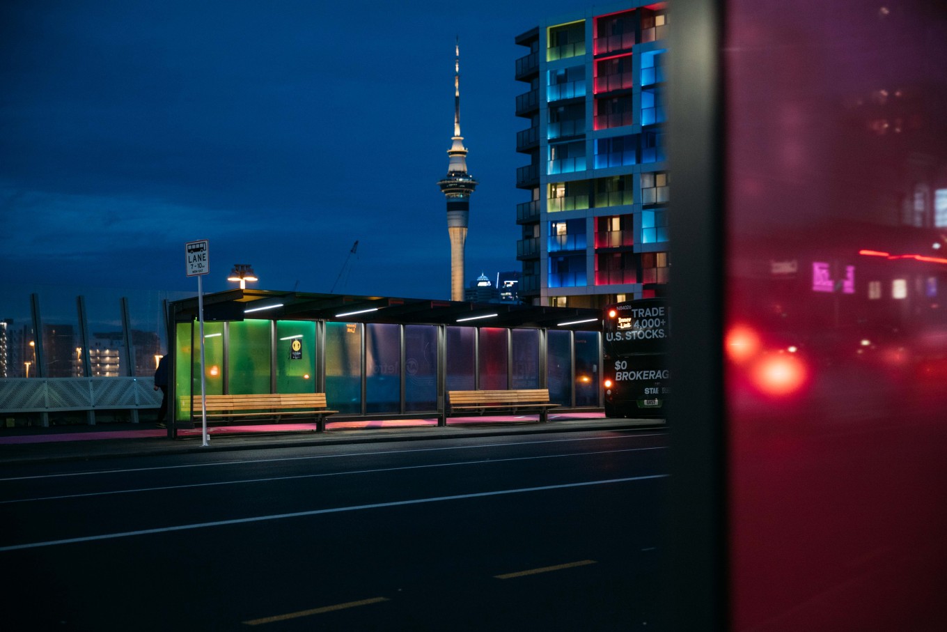
Photo credit: KBA.
2. Cycleways
Separated bike lanes along each side of Karangahape Road are popular for active commuters, as are new separated cycle lanes on Canada Street and East Street linking up with existing cycle routes such as Te Ara I Whiti – The Lightpath. Pitt Street and Vincent Street are also now linked into the cycle network.
3. Public art
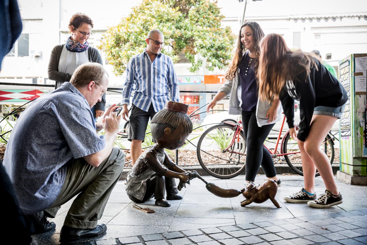
Thief sculpture on Karangahape Road.
Karangahape Road has playful public art on almost every corner. Favourites are Twist and Thief, both by Tanja McMillan and John Oz. Small in stature, Thief is a bronze sculpture of a boy and a piglet playing tug of war over a turnip. And Twist is a charming, cartoon-like sculpture of a young girl and her elephant. To find other artworks along Karangahape Road, digitally geo-locate them at aucklandpublicart.com.
4. Rain gardens
Rain gardens bring welcome splashes of foliage to the street, while supporting the city’s stormwater system. Rain run-off flows into the gardens where the soil and plant roots absorb and filter contaminants before the water flows into the stormwater network.
5. Engraved metal discs
Under wooden street furniture you’ll see stainless-steel circular inlays in the paving. Designers drew inspiration for the discs from shell pathways, once said to be found along this ridgeline, reflecting the moonlight and lighting the way. The discs reflect the colours and patterns of light in present day Karangahape Road. Artist Tessa Harris (Ngāi Tai ki Tāmaki) guided the design of both the pāua bus shelters and steel discs.
6. Rainbow crossings
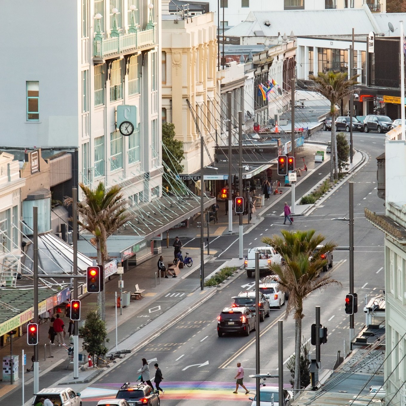
An aerial shot of Karangahape Rd. Photo credit: Landlab.
Karangahape Road wouldn’t be true to its identity without a celebration of the rainbow community, embraced by this street throughout its evolution. Walk the two rainbow crossings and feel the vibe of this colourful, inclusive neighbourhood.
7. Beresford Square
Arrive in Beresford Square, the northern forecourt of Karanga-a-Hape Station, and you’ll notice Te Pō - a striking 6-metre vent embellished with bronze-cast manaia (figures) on all four sides. The figures represent kaitiakitanga (stewardship and protection of the natural environment). You’ll see a weathered patina reflecting the texture of pounamu on the surface of each bronze figure. The square’s paving also tells a story. The pattern resembles dappled light shining through a forest canopy, symbolic of Tāne Mahuta, God of the Forest. The lead mana whenua artist for Beresford Square was Reuben Kirkwood (Ngāi Tai ki Tāmaki).
8. Mercury Lane
Mercury Lane and station. Photo credit: Auckland Transport.
In Mercury Lane – now a pedestrian-priority space - you will see lighting posts depicting the story of Tāne Mahuta. As the legend goes, with tall trees acting as tokotoko (posts), Tāne held up the sky and let in the light. You’ll also see four engraved kōwhatu (volcanic rocks) in the landscape of Mercury Lane and surrounding streets – these are symbols of life force that acknowledge the flow of people, energy, and stories from all directions and walks of life. Overhead lighting and star motif projections will mark Te Whānau Marama, the light-giving family – the sun, moon, and stars. The lead mana whenua artist for Mercury Lane was Pāora Puru (Ngāti Te Ata Waiohua).
9. St Kevin’s Arcade
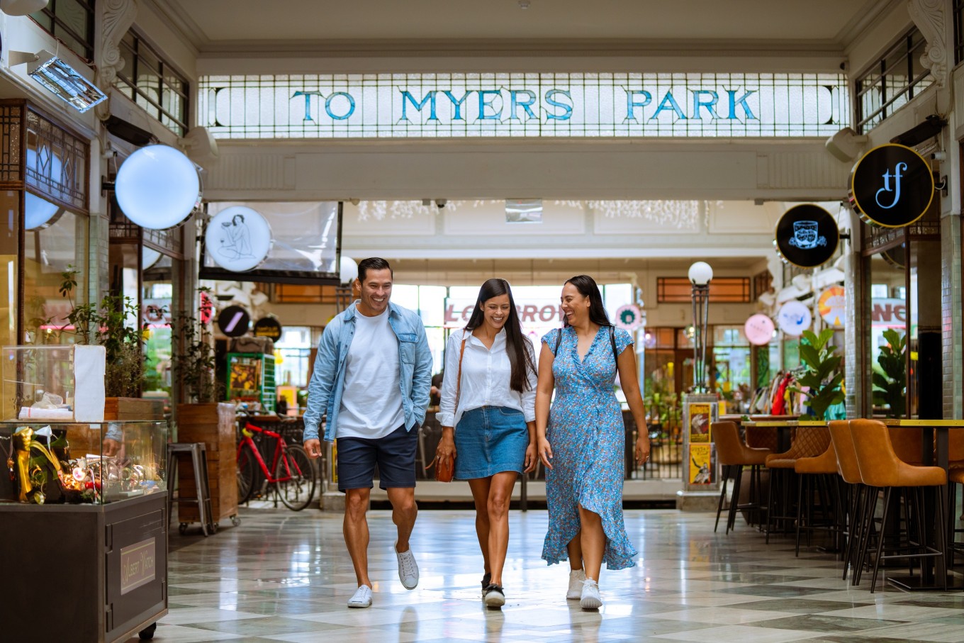
St Kevins Arcade. Photo credit: Tātaki Auckland Unlimited.
Built in 1924, St Kevin’s Arcade is one of the city centre’s heritage jewels. Home to thriving restaurants and clubs, it sits in the heart of this creative, culinary neighbourhood. Take a moment to pause and admire the view of Myers Park.
10. Myers Park
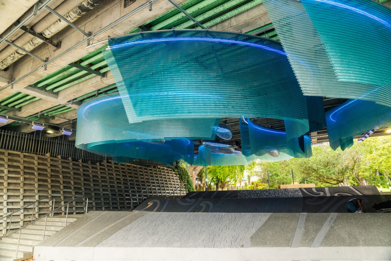
Waimahara artwork (by Graham Tipene) at Myers Park.
Myers Park is a place where art truly meets infrastructure. 344 mature trees provide shade in the park, attract birds, improve air quality and absorb carbon. The park’s award-winning artwork Waimahara is interactive - sing a special waiata and the artwork will listen and respond, accompanying you with an awe-inspiring display of light and sound. Graham Tipene (Ngāti Whātua, Ngāti Kahu, Ngāti Hine, Ngāti Hāua, Ngāti Manu) led this ground-breaking art project.
Read more about the benefits of CRL on OurAuckland.
City Rail Link information brochures are available in eight languages on the Auckland Transport website.