
Between the sweep of the Waitākere Ranges and the glittering stretch of the Hauraki Gulf, Auckland has abundant natural riches.
Exploring on foot means slowing down and discovering pockets of native bush alive with birdlife, and expansive views. For your next adventure, check out one of Auckland’s great walks.
Waitawa Kōtare Path
This track is a six-kilometre loop around Waitawa Regional Park. Connecting picturesque bays, areas of regenerating coastal bush, and wetland environments, the Kōtare Path is a string of scenic wonders.
You’ll enjoy sweeping views from various points along the track. The walk takes around 90 minutes and the track is well maintained, although it can be steep in sections.
Kitekite Falls Path
The Kitekite Falls walk is one of Auckland’s premier bush walks, and a highlight of visiting Piha. The track is around 1.5km each direction, 3km in total, with a gentle climb and a few stream crossings along the way. Don’t let this put you off, though; the track is well-maintained and alternates between gravel and boardwalks.
The rich forest is typical of the Waitākere Ranges, and of course, at the end of the walk is the stunning waterfall.
Coast to Coast Walkway
Walk from the east coast of New Zealand to the west, from Waitematā to Manukau. This 16-kilometre trail takes roughly four hours, covering some of Auckland city’s most impressive scenery along the way.
You’ll pass through the Auckland domain, climb iconic maunga such as Maungawhau (Mount Eden) and Maungakiekie (One Tree Hill), and discover scenic and peaceful suburbs of the city.
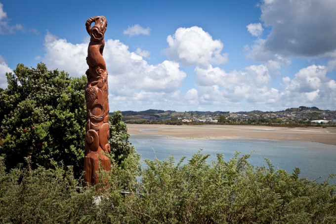
Te Ara Tahuna/Ōrewa Estuary Path
The Te Ara Tahuna is a loop track that takes around 80 minutes. The wide, flat trail traces the water’s edge around the Orewa estuary and passes through patches of native bush and grassy green parks. Along the way, you’ll see Māori carvings that recognise the area’s historical significance.
This is a great walk for people of all fitness levels. Combine the walk with time at nearby Orewa beach for a great day out.
Duder Farm Path
Duder Regional Park is located on the Whakakaiwhara Peninsula, which juts into the Hauraki Gulf. The Farm Path loops around the pōhutukawa fringed peninsula, offering striking views across the water at many points on the 4.3-kilometre trail. The Oturia Trig station is the highest point on the trail, with panoramic views of the gulf. Duder is a working farm so you will see cattle and sheep peacefully grazing.
While there, follow the walk to Whakakaiwhara Pä and see the earthwork remains of this fortified Māori settlement, a 2.5 hour return route.
Protect our kauri
Kauri dieback in Auckland is a serious problem and it’s important we all play our part to prevent the spread of the disease.
If you enter or leave a forest/area with native trees anywhere across the region, here are three easy steps you need to remember:
- Scrub– clean all soil off your footwear and gear.
- Spray– your footwear and gear with disinfectant at every cleaning station you encounter. Kauri dieback can be spread by just a pinhead of soil.
- Stay– on open tracks and off kauri roots.
Always check the Auckland Council kauri webpage before going for a walk to find out what tracks are currently closed.